|
Use this dialog to select the options for import and exporting LandXML files.
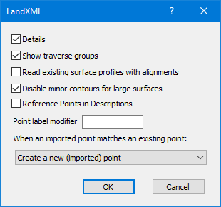
Details
Display the imported data in the Message View. You'll see sections like [Points] and [Parcels] depending on the specific LandXML data you choose to import.
Overwrite existing data
Choose what to do if an imported point label already exists in your survey.
Show traverse groups
Turn this option on to insure that Traverse Groups are displayed after the import.
TPC uses traverse groups to differentiate LandXML Parcels from Alignments. In TPC, both are traverses, but TPC places Parcel traverses in the Parcels traverse group and places Alignments traverses in the Alignments traverse group.
Read existing surface profiles with alignments
Turn this option on to read the ProfSurf data with alignments.
TPC can easily create this same data as needed by transecting the existing surface imported from the Land XML file.
Disable minor contours for large surfaces
Turn this option on to NOT draw minor contours for surfaces with more than 1000 faces.
Surfaces with 1000 faces may start to draw more slowly and look more cluttered with the minor contours turned on. By turning them off with this option, the surface can more easily be evaluated once inside TPC. Of course, you can always simply edit the surface and turn minor contour back on.
TPC also ignores the minor contour layer be default. Again, this is a better experience inside TPC since the cursor does not interact with what could potentially be many minor contour lines.
OK
Accept the changes you made.
Cancel
Close the dialog without changing the LandXML settings.
Related Topics
LandXML
Importing LandXML
Importing Data
Editions
Professional
|

