|
You can update the coordinates of an existing survey point or create a new survey point at a distance and direction from another survey location. Use this routine to create random points that can be plotted in the current drawing or to tweak the location of an existing point.
•Choose COGO | Compute Coordinates See Accessing COGO.
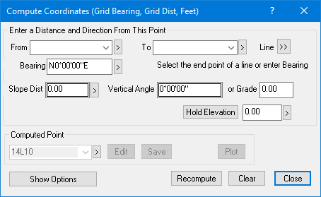
•From the Compute Coordinates dialog, modify the From point, direction and distance. You can use equations to get the distance and direction from existing points or pick the data from the current drawing.
•Recall an existing point or enter a new point label in the Computed section.
•Choose Save to create a new point or update an existing point.
The distance and azimuth or bearing are added to the From point to generate the computed point.
Geodetic vs Non-Geodetic
You can use this dialog to compute both geodetic and non-geodetic foresights. The computation is based on the distance type you use in the dialog.
Holding an Elevation
If you have an elevation you want to hold for the computed point (a building pad elevation for instance) just enter the elevation or pick it from the current drawing. The Hold Elevation will change colors to indicate it is being held. To release the elevation, left click the Hold Elevation button.
Modifying an Existing Point
It's easy to modify the position of an existing point. Just select that point in the Points Manager or Traverse View or position the cursor over it's point label or point symbol in the current drawing then right click and choose COGO | Compute Coordinates. If TPC can identify the traverse the point is from, it will use the previous control point to initialize the From point, Slope Distance and Bearing or Azimuth. This lets you quickly tweak the position of an existing point.
Related Topics
Offset Interval dialog
Using COGO
Editions
Personal, Premium, Professional
|

