|
The Trimble DC10.7 format is similar to the Sokkia SDR format but uses its own record numbers.
Importing Trimble Files
•From the TPC Desktop choose File | Import.
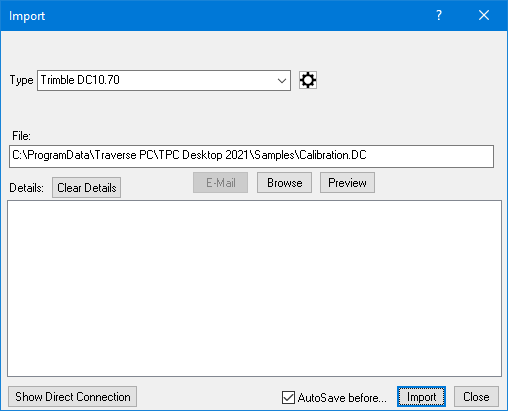
•From the Type list, choose Trimble DC10.70 then settings you want by clicking on the [...] button.
•Enter a file name or choose Browse and select the file you want or choose Direct Connection.
•Choose Import.
•Tell the device to send its data.
TPC will display the File Save dialog. Enter a file name and folder to store the data in.
The Import dialog will indicate when the import is complete.
TPC will add a new traverse to the survey and put all of the imported points into it. The imported points also show up in the Points Manager. If you don’t want the traverse you can delete it. The points will remain in the Points Manager.
Correct Slope Distance for Prism and PPM
Beginning with TPC Desktop 2025, you can correct slope distances for prism offsets and PPM in the Settings dialog by choosing
[x] Apply Prism Constant if Found
[X] Apply PPM if Found

They are reported in the Details as seen in this example.
SS:306 Desc:RBF
SD:592.0272 ZA:91.19639000d HC:189.44091000d HT:5.00
Applied prism offset 0.072, Applied PPM -0.00848
Supported Records
0 header info
2 station - can be converted from ground to grid on import
4 collimation
5 atmosphere
7 backsight bearing
10 job name
13 comment
49 datum (reported in details only)*
50 horizontal adjustment (reported in details only)*
56 survey mask*
57 antenna height
59 quality control 2*
61 instrument
64 projection (reported in details only)
65 local ellipsoid (reported in details only)
66 global position (LLh)
67 GPS Vectors*
68 local position (LLh)
69 grid position (x,y,z) - can be converted from ground to grid on import
70 ground vectors
71 survey event*
73 RTK reference point (stored in TPC as an occupied point)
75 instrument
77 target height
79 observation (angles and distance)
80 ground observation
81 vertical adjustment (reported in details only)
82 survey event
A0 stakeout point design*
A5 point grid deltas*
B6 long feature code*
C4 mean turned angle*
C6 quality control 1*
C7 instrument precisions
C8 coordinate system
D5 local site settings
D6 line*
D7 circular arc*
E0 station
E3 rounds MTA residual*
E4 instrument **
*First supported in TPC Desktop 2018 R2 (July 2018)
** First supported in TPC Desktop 2025 (April 2025)
TPC may support additional records as requested.
Header Record
TPC reads the following settings from the header info - angle units, distance units (feet or meters), pressure units, temperature units, angle units and coordinate sequence.
Converting Coordinates
Trimble uses the term Grid coordinates, which are one of the following, depending on whether or not Local Site Settings have been applied in Trimble:
•ground coordinates (local site coordinates) if the user has applied what Trimble calls Local Site Settings
•ellipsoid coordinates if the user has not applied Local Site Settings
You can use the Convert Coordinates option in TPC to automatically convert the imported Trimble coordinates to what you want in TPC.
Import grid coordinates if your TPC survey uses geodetics
If you have selected a CRS (Coordinate Reference System) for your survey, you will probably want imported coordinates from Trimble to be converted to TPC's grid.
If the file you import includes a record 135 Local Site Settings, and the included 'ground factor' is something other than 1.0000, TPC automatically converts the imported coordinates from ground coordinates to ellipsoid coordinates. You can also choose the [x] Convert Coordinates option in the settings dialog.
Import ground coordinates if your TPC survey does not use geodetics
If you are not using a CRS for your survey, your survey is already at ground (what Trimble calls Local Site). Furthermore, without a CRS, TPC has no way to convert grid to ground, so you will want to import ground coordinates from Trimble.
Exporting Trimble Files
If a traverse or traverses already define the data you want to export, go to the Traverses Manager. If you want to export only certain points, go to the Points Manager.
•Select the traverses or points you want from the views.
•From the TPC Desktop menu choose File | Export.
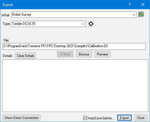
•From the Type list, choose Trimble DC10.70 then settings you want by clicking on the [...] button.
•Enter a file name or choose Browse and select one or choose Direct Connection.
•Prepare the device to receive data.
•Choose Export.
The dialog box will indicate when the export is complete.
Changing the Header Information
The first few lines of any Trimble DC10.70 file contain some basic information about the job. These lines must be formatted properly to read into the device. Some of the information in these first few lines is instrument and version specific.
To edit the header information for the files that TPC writes, open TrimbleDC10-70.dat found in the program data folder.
Related Topics
Trimble
Editions
Personal, Premium, Professional
|

