|
When you import data into a survey, TPC creates traverses for the imported data automatically or gives you option, as it does with the ASCII import.
Automatic Traverse Creation
When you import raw data, whether its from a CSV file, total station or GNSS RTK, TPC automatically creates a traverse to hold that raw data along with the survey points it references.
These traverses are added to the Imported traverse group in order to help you organize your data.
The following formats also create traverses on import.
ESRI Shape/GIS
When you import GIS data into the survey (not into a drawing), TPC converts parcel shapes into traverses, with each parcel getting its own traverse. See Using Shape Files.
KML/KMZ
When you import KML or KMZ files from Google Earth, TPC converts the Placemarks into traverses. See KML Import.
LandXML
LandXML files distinguish between Parcels and Alignments, both of which import as traverses, which TPC automatically places into their respective Lots and Alignments traverse groups. See LandXML.
Pacsoft, C&G, Softdesk (DCA)
Many of the file formats that TPC imports have some kind of convention for what they call figures or parcels. TPC supports these and imports them into their own traverses.
Manual Traverse Creation
Some file formats, like ASCII and TDS CRD, are just survey points with coordinates or geodetic positions. TPC always imports these points into the survey, but creating a traverse is optional.
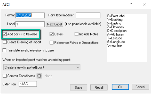
To create the traverse on import, you must choose [x] Add points to traverse in the settings dialog for that file format, as shown here for the ASCII import.
Related Topics
Traverses
Creating Traverses
Importing Data
Editions
Personal, Premium, Professional
|

