|
These settings allows you to specify how data should be imported from a GNSS CSV file.
See Import Settings for settings not shown here.
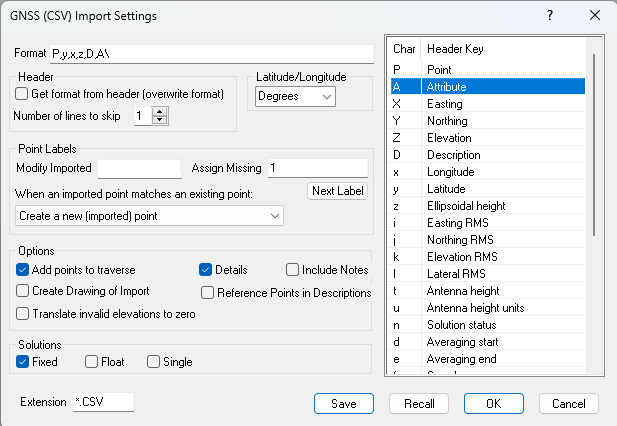
Import Format
Use the characters displayed on the right side of this dialog to specify the format of the file to be imported. y = Latitude, x = Longitude, etc. All of the characters are defined in GPS/GNSS Data.
You can also have TPC parse the header line to determine the import format. See GPS/GNSS CSV Files.
Ellipsoid Height vs Elevation
You use z for ellipsoid height and Z elevation (orthometric height or Mean Sea Level).
Skipping Columns
To skip columns that are blank or that you don't want to read, include a ? or extra comma.
In the following example, the file includes columns for Code,East,Northing,Elevation but no data.
You could specify the format P,,,,,D,y,x,z\ to ignore those columns.
Name,Code,Easting,Northing,Elevation,Description,Longitude,Latitude,Ellipsoidal height
501,,,,,Set Spike 2/28/23,-122.94333368,46.34807044,19.741
502,,,,,"Fnd 2/28/23 5/8"" RC ""35713"" ag",-122.94348955,46.34922481,17.088
Header
GNSS CSV files can contain lots of columns with various data, some of which TPC uses and some of which it doesn't.
Use the [X] Get format from header (overwrite format) to have TPC generate the Format for you. You can also skip the header line(s) and specify your own format if TPC can't decipher a header. See GPS/GNSS CSV File Headers.
Latitude/Longitude
Select one of the options for how the latitude/longitude data you are importing is formatted. See Latitude & Longitude Formats.
Translate invalid elevations to zero
Any elevations that are outside of the user defined limits in Program Settings will be set to zero.
Details
Turn on [x] Details to get a report of the GNSS data TPC gets from each imported point. See Viewing Imported GPS/GNSS Data.
Solutions
Select one or more solution types you would like to import. This allows you to skip any solutions you don't want.
In very general terms, they are defined as follows
Fixed
Fixed solutions are observations that are generally within 1 cm or 0.03 ft of the true position.
Float
Fixed solutions are observations that are generally within 0.5 to 1 m or 1 - 2 ft of the true position.
Single
Fixed solutions are observations that are generally within 3 to 5 m or 10 - 30 ft of the true position.
See Types of GPS/GNSS Supported.
Extension
Enter the file extension your CSV files use. The default is CSV.
Save / Recall
Once you have a format that works for your data collector or client, you can save it using a descriptive name like “Oregon GRNS” and recall the format as needed. See ASCII Save / Recall Settings.
OK
Applies the changes you have made and returns you to the previous window.
Cancel
Returns you to the previous window without making any changes.
Related Topics
Using GPS/GNSS
GPS/GNSS Data
GPS/GNSS CSV File Headers
Importing GNSS CSV
Exporting GNSS CSV
GPS/GNSS CSV File Headers
Viewing Imported GPS/GNSS Data
Types of GPS/GNSS Supported
Save / Recall Settings
Editions
Premium, Professional
|

